Progress Report: December 20th 2023 by Consortium for Wildlife Bycatch Reduction

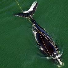
The Consortium for Wildlife Bycatch Reduction

Progress report – December 20th 2023

Objective 1: Determine the at-sea distribution and abundance of small-cetaceans (with particular emphasis on Burmeister’s porpoises) in the coastal waters of one of the main ports for Peruvian coastal fisheries.

To conduct at-sea surveys in Pucusana we will follow a distance sampling protocol for cetaceans. We will replicate the protocol we implemented during Salaverry and Paracas at-sea surveys. The at-sea survey team will be comprised of 5 members. Two dedicated observers will be located at the observation platform, situated as high as possible on the vessel. Observes will be stationed on either side of the vessel scanning for marine mammals from the front to their side abeam with naked eye and use binoculars to aid species identification. To fulfil with the distance sampling methodology, angle and distance will be recorded at first sighting, using an angle board fixed to the observation platform and naked eye or using 10x42 reticle binoculars, respectively. In addition, two data loggers will record marine mammals sightings whenever they occurred and environmental conditions every 30 minutes. Observers and data loggers will rotate every 30 minutes to avoid fatigue and to limit continuous observation time to one hour per person.

Data will be recorded using the custom-written Cybertracker app. We will use the data sheet template previously used in Salaverry and Paracas but adapted to our new study area Pucusana. Paper sheets will be used as backup to data collected using the app. Information to be recorded in each survey include: effort data (start and end time and GPS positions in 10-30 second intervals), survey conditions every 30 min (Beaufort, visibility, wind speed and direction, sun glare, swell and sightability), environmental information (depth and sea surface temperature when possible using the vessel echosounder), sighting data (angle, distance, GPS position, species ID and ID confidence, group size, behaviour, sighing cue and aspect towards the vessel) and anthropogenic activities. 

Survey routes (tracklines) have been designed to be implemented in Pucusana for a total of 15 days. The first day will be dedicated to run a survey trial to accommodate the team and equipment in the vessel and revisit the methodology. Tracklines were designed considering daylight hours, the maximum travel speed adequate to target species behaviour, set to 6 knots (11km/h), and to cover representatively the habitat characteristics of the study area (Fig. 1). Modification to tracklines could be expected based on in situ logistic and environmental conditions.

Objective 2: Determine the spatial overlap and scope of interactions with coastal fisheries using at-sea observations and fisher interviews.

The accomplishment of this objective is related to activities conducted for objective 1 and activities conducted towards objective 3 and 4 that will be specified in the next sections.

Objective 3: Use interview-based surveys with fishers to characterise the interactions between net fishers and small-cetaceans and current estimate bycatch rates.

A questionnaire previously implemented in 5 Peruvian ports will be used to interview fishers in Pucusana. Maps to collect spatial information about fishing areas, small cetacean sightings and bycatch have been prepared considering Pucusana fishers potential fishing areas.

As interviews to fisher contemplate the direct participation of humans, Ortiz Alvarez and Heinrich submitted an ethics application form to the University Teaching and Research Ethics Committee (UTREC) from the University of St. Andrews to conduct the ethical review and approval of the research activities that will be conducted during the interviews to fishers in Pucusana. We are now reviewing minor comments for its final approval.

Interviews in Pucusana will be conducted after at-sea survey and will target 66 gillnet fishers (vessel captains) from Pucusana to cover at least 20% of gillnet vessels.

Objective 4: Trial a smartphone app with fishers to collect data on at-sea distribution and frequency of encounters with marine mammal species during fishing activities.

We will use the new online version of the custom-written Cybertracker app. A data collection sheet to be used by fishers during their fishing activities has been designed. Information to be collected by fishers include fishing activity (target species, ports of departure and arrival and number of sets), marine mammals sightings (species ID, group size, sea surface temperature and depth when possible) and marine mammal bycatch (species identification, number of animals entangled, type and depth of net, mesh size, depth and sea surface temperature when possible).

Date and GPS positions is automatically recorded while using the app.

The cyber tracker app will be installed on fishers smartphones and the data sheet template will be supplied to them through a link using WhatsApp, one of the most frequently social media apps used by fishers in Peru. Through the link fishers will be able to access and use the data sheet designed using the Cybertracker app.

Fishers will receive training for data collection using the Cybertracker app.

Data collected by fishers will be available at the online.cybertracker.org webpage and will be managed by the administrator, Clara Ortiz-Alvarez.

Ortiz Alvarez travel to Peru from St. Andrews on December 11th to start coordinating activities for fieldwork in Pucusana on February 2024. She is now coordinating vessel charter, accommodation and other logistic arrangements.


Figure 1. Tracklines designed to be implemented in Pucusana during at-sea surveys on February 2024.

Featured Bycatch Species